We can now track animal panic from space. Here's why it matters

 Sergio Izquierdo
After decades of development, wildlife surveillance has finally come of age. The new Icarus satellite is tracking signals hidden in animal behaviour – which could save the lives of cheetahs, rhinos and elephants.
On a blustery morning at the start of Namibia's winter, a pickup truck idles to a halt on the edge of Okambara Elephant Lodge, a private wildlife reserve 100 miles (161 km) from the capital of Windhoek. Two women and two men – one armed with a rifle – step out onto the red soil.
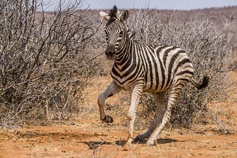
Throughout June, Okambara is a bone-dry expanse of thorny trees and shrubs. Although the Sun is shining, cool winds keep the park's animals vigilant, as the wildebeest, zebras and giraffes sniff out scents on the breeze, which could alert them to danger now moving through the bush. Yet the skilled intruders remain hidden downwind.
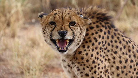
As the hunters close in on the game, the rifle lefts out a boom. Fear jolts through each species: springbok bounce, skittish zebra break into gallop, and the wildebeest turn and race, some not stopping for hundreds of metres, as they barrel away from danger into Okambara's wide-open salt plains.
Scientists are now able to study these signals written in animal panic thanks to a new satellite system, named Icarus, which is tracking animal movement and behaviour on an unprecedented scale from space. By monitoring how animals react to the presence of human intruders, conservationists hope to pinpoint and crack down on poachers.
Patterns of panic
Over three days in mid-2024, the intruders in Okambara make around 30 of these salvoes – all captured through the lens of an unmanned drone that hovers overhead. From this sky view, the rapid dispersal plays out, again and again, with animals tracing out signature patterns of panic and withdrawal.
The team of hunters fires dozens of rounds and the game scatters, except for the giraffes, which usually remain impassive and calmly look on from their raised vantage point. Yet by the week's end, not a single victim has fallen to the hunter's gun. That's because, unlike the poachers who have killed hundreds of rhinos in southern Africa, this hunting party is not here for slaughter. Instead, today's team are scientists doing their best to simulate the arrival of a deadly threat.
The armed interlopers – an ornithologist, an expert game hunter, and two wildlife researchers – are part of an experiment to develop a real-time tracking system that could save the lives of Africa's most trafficked animals. By recording the distinctive patterns traced by different species as they react to a hunter, the team ultimately aims to train an algorithm that can send out a warning alarm to rangers.
These warning systems are still in development at nature reserves – but the recent launch of a wildlife tracking satellite, dubbed the "Internet of Animals", aims to link up a truly global system of real-time alerts.
 Max Planck Institute of Animal Behavior
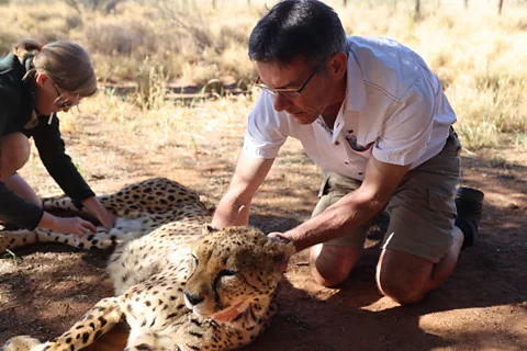
Okambara, a flat 169 sq km (66 sq miles) reserve, has become the "perfect site to test the system," says Sierra Jane Mattingly, an ecologist at the Max Planck Institute of Animal Behavior in Germany. Here, 5% of all large animals have been fitted with GPS tags that continually monitor their location. But the real goal is to help wildlife in the most precarious places worldwide.
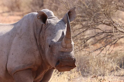
The lessons learned here are helping in the battle with poachers in national parks in South Africa – home to the world's largest rhino population – and aims to safeguard the free-roaming wildlife populations in currently unmonitored places like the Congo Basin.
The project is the realisation of a long-held dream of Martin Wikelski, the ornithologist on hand in Okambara. Wikelski, a world-leading movement ecologist who heads the Max Planck Institute, hopes to tag 100,000 animals across the planet by 2030, with the goal of understanding the signals hidden in animal behaviour. As they beam out their movements to receiver towers or satellites, animals can collectively act as "sentinels" to protect rare giants like rhinos, he explains.
"We have the other animals protecting the rhinos because they tell us when the butchers are coming," Wikelski says, standing behind a model of a satellite, named Icarus, during a Whitley Award conservation conference in London, shortly before the project launched in November.
With the addition of small ear-mounted tags, rhinos' competitors and nearby carnivores are turned into their protectors, making allies of cheetahs, zebras and giraffes – arguably the perfect sentinels because rows of the long-necked animals will often remain still and observe threats from a safe distance, with their heads all pointing in the direction of poachers, he says. "So we know where the butcher is."
Smart watches for wildlife
This grand vision of wildlife connected through network technology is all made possible by tiny pieces of electronics that thousands of animals now carry. Wildlife tags are becoming miniature marvels, says Timm Wild, an electrical engineer at Max Planck. Some can track not only GPS position but their wearer's activity, heart rate and body heat, as well as operating a mobile sensor taking readings of surrounding temperature and atmospheric pressure.
Today's tags are tiny enough to be carried by birds or even butterflies, like the rice-grain-sized chip developed by New Jersey-based Cellular Tracking Technologies to track monarchs as they migrate thousands of miles across North America. Wild explains that the cutting-edge sensors are powered by supercapacitors – long-lasting, easily rechargeable alternatives to batteries – meaning they could allow us to see where long-lived species spend each day of their lives. "Lifetime tracking is a challenge that is partly solved now," Wild says excitedly.
 Max Planck Institute of Animal Behavior
Each of these innovations overcomes a major drawback of a technology that has been around for decades. Animal tags were first used in 1970, when researchers in Wyoming fitted an elk named Monique with a 10kg (22lb) satellite collar, which broadcast an analogue VHF signal. In the decades that followed similar tags beamed new discoveries about ungulate migrations and whale journeys. But these heavy, old tags remain restrictive and have low accuracy. Nearly four decades later, they were still too heavy for 75% of birds and mammals.
Wild, an electrical engineer for carmakers like Daimler and Mitsubishi, began working with wildlife in 2019, and was surprised to see how primitive the tech being used in scientific research was. Digital "Internet of Things" sensors had taken off in the previous decade, fuelled by the rise of consumer technologies. Tracking devices could be precision-measured to centimetre scale and intelligent tracking systems could work out where they were located even when satellite connection was not possible, such as when a car following GPS turns into a tunnel or a blind spot between skyscrapers.
"If you put that technology on a bird or a monkey, you suddenly can see where in the tree they sit and what they actually eat," Wild says.
More like this:
Computing in the mud
Wild's team of about a dozen at Max Planck aimed to close the "huge gaps" between the tech available in consumer electronics and in the field.
Okambara is a good example of the limitations of today's tech. The current system can transmit 12-byte packages of data about every 10 minutes to a transmitter in the middle of the park. During the poaching simulations, researchers saw isolated GPS points and needed the drone to fill in the rest of the story.
Transmitting data back from the far corners of the Earth is a major challenge, Wild says, and heavier tags and bigger batteries are needed to incorporate more memory. His team are working on each of these challenges: "We develop our own prototypes: our own hardware, own software, own 3D printable housings," he says.
 Max Planck Institute of Animal Behavior
But, for now, newer tags are finding work-arounds that condense raw data into useable insights before transmitting. While some have called this "artificial intelligence on tag", Wild says that's a stretch: "It's like a very, very basic algorithm" that can tell us if a bird has hit a rainstorm or emerged into the sun.
These kinds of real-time notices are especially valuable in conservation, says Mattingly, for example telling us if a particular animal is hunting or resting. "That is great because we can very clearly see if an animal is dead or not," she says. Projects like Okambara tag both ears to avoid false alarms, as wild animals are continually finding new ways to knock off a tag or crush a tag. But if both ear tags are not moving, they send out a "mortality notice" that alerts a ranger to check on them.
This kind of processing means that tags are now equipped with a level of "situational awareness" about what's normal and not normal for that animal, says Wild. "For example, we have a lot of data collected about how a zebra normally behaves. Now suddenly it behaves outside of this usual movement pattern – we can very quickly detect if it's, for example, sick or if it's injured – and then hopefully help the animal."
Computing in the mud
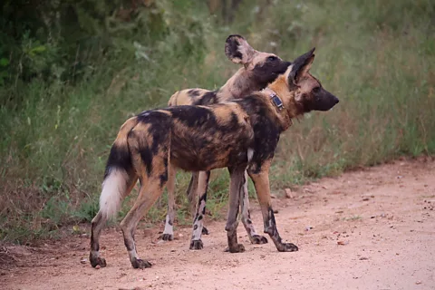
This approach has been trialled at Kruger National Park in South Africa, where it has helped rangers to pinpoint wild dogs caught in snares. Out of the 400 wild dogs in the park, some 80 have been freed from snares, showing a major impact on the population, says Louis van Schalkwyk, a wildlife veterinarian based at Kruger, who leads the tricky work of putting tags on wild animals there.
The biggest goal is safeguarding Kruger's 3,000 rhinos. More than 10,000 rhinos have been poached in South Africa over the last 15 years, according to the International Rhino Foundation. Kruger has long been the species biggest single stronghold but 175 rhinos were killed by poachers in 2025.
"In Kruger, I think the challenge is that it's a huge place," says van Schalkwyk. Spanning 19,485 sq km (7,523 sq miles), about the size of Israel, it requires more than 30 of the receiver towers in Okambara, and orders of magnitude more tagged animals to get the same sentinel effect.
 Max Planck Institute of Animal Behavior
Kruger has deployed about 3,000 ear tags on 1,500 rhinos, antelopes, zebras, kudu, oryx and elephants. Van Schalkwyk hopes to build a better "conservation dashboard" by integrating alerts with Earth Ranger, a mapping system that already shows tagged animals and rangers on foot, truck and helicopter.
Currently, tags remain better at providing retrospective data than live updates, he explains. When rhinos have been poached, it can give an indication of the moments leading up to the attack, such as where the attackers had arrived from. "When it works, it's incredible," he says.
He's confident the poacher system will get there but in Kruger it's not yet a tool that rangers can use every day. "We don't have an alarm going off here saying there's 10 zebras telling us there's someone walking in the bush," he says.
A lot of things have to work perfectly together for this to happen: "You have to have perfect coverage. You have to have a really good antenna on a very tiny device, which is really tricky". Then you have to attach it all safely to the ear of "an animal that loves mud and dirt".
The 'Internet of Animals'
In late November, Wikelski was nervously preparing for the launch of a satellite that could change the scope of wildlife tracking once again – extending it from a handful of parks to a truly global project. While analogue sensors have communicated basic information with satellites for decades, precise digital tags are usually limited to ground connections. By mid 2027, Max Planck's Icarus project aims to have six receivers in orbit, making it possible to receive real-time data on animal movements across the planet. Wikelski dubbed the system the "Internet of Animals".
The first is launching as part of a €70m ($83m) EU-backed fleet of small scientific satellites, serving as a "laboratory in orbit". Wikelski was stuck waiting all November for the green light from SpaceX to launch the initial Icarus probe into orbit from Vandenberg Air Force Base in Santa Barbara, California.
By the end of the month, he'd endured weeks of false-starts, with four last-minute reschedules, as the US government shutdown resulted in shortages of flight controllers. It felt like being a kid on Christmas Eve, he says, rushing around willing the time to come, "and maybe by 14:00 or 15:00, you're done," he laughs. "It's stupid."
At 10:44, the condensation-covered pencil-like Falcon 9 rocket erupted from the launch pad, rising on a column of fire and carrying the satellite into orbit. After the years of waiting the whole thing was over in a flash, he says. "Maybe two or three hours afterwards, we already had the confirmation that the satellite is on the right orbit, is communicating, which is really the only thing a satellite has to do." In May, Icarus launched a second system into orbit – the microsatellite "Raven". Following a few months of testing, the system will begin receiving data from animals' tags this summer.
For animal tracking, the shift from land-based receivers to satellite systems will be like the shift from landlines to mobile phones, Wikelski says. It's unlikely to solve Okambara's data bottleneck any time soon.
"I think the biggest impact will be outside of those areas," Wikelski estimates, in places like the Congo Basin and the Amazon, where animals with large ranges have to navigate wildlife reserves, roads, farms and human settlements. We now have a way to answer questions about the fate of migratory birds and elusive creatures like jaguars, tigers and snow leopards, he says. "What do they need? What else do they need during climate change? Are they going back to certain refugia?"
The core, "absolute key" questions like "where are wild animals living and dying?" have always appeared unanswerable, he says. "People have somehow accepted 'Oh, we will never know that,'" Wikelski says. "We can finally do it."
--
For essential climate news and hopeful developments to your inbox, sign up to the Future Earth newsletter, while The Essential List delivers a handpicked selection of features and insights twice a week.
